Appendix A: Basemap
All indicators rely on a land cover map to measure pre- and post-planting benefits. For this project, we used the EcoservR toolkit6 to develop a habitat baseline for all of England. This map is based on the OS MasterMap Topography framework, and as such is much more thematically and spatially detailed than simpler land cover maps typically used in natural capital assessments (Figure A.1). In practice, the indicators could be applied to any map, provided that the habitats were reclassified to codes understood by the models’ lookup tables. This allows better accuracy in measuring environmental outcomes (driven partly by the previous land use), more robust land use summaries, and a multi-purpose land cover map which we hope will find several more applications beyond the scope of this project (see Legacy).
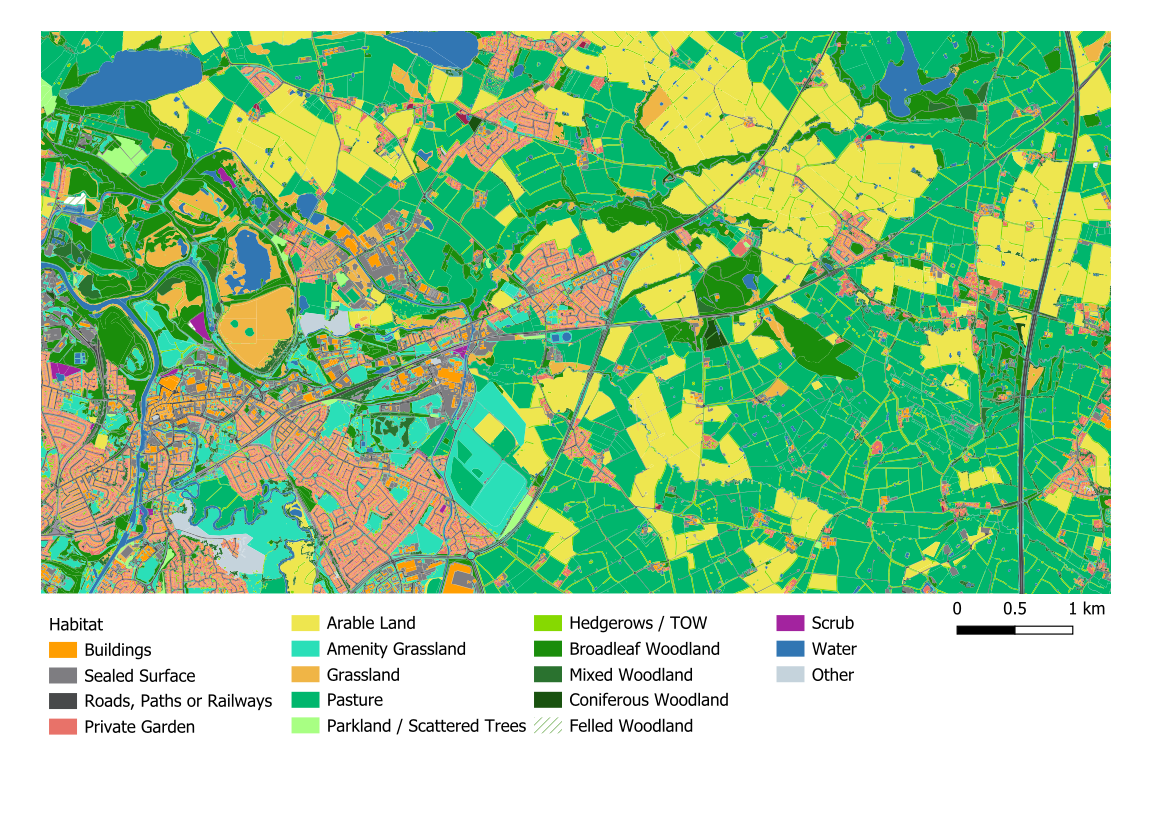
Figure A.1. Sample of the habitat baseline used for all analyses in this report. The baseline uses OS MasterMap Topography Layer for its spatial framework, and integrates additional environmental datasets to support more detailed habitat classification. © Crown copyright and database rights 2026 Ordnance Survey AC0000805307.
Building the basemap
The habitat basemap is built through a series of automated processes within EcoservR, where the user only has to supply the relevant datasets (Table A.1). The tool then extracts information from these sources into OS MasterMap Topography polygons. A set of classification rules are then applied to assign the most likely habitat type to each polygon. The resulting habitats align with the Phase 1 habitat classification system commonly used for ecological surveys.
This process produces a detailed habitat map, highly accurate at the broad habitat level and with varying by-class accuracy depending on the specificity of habitats and level of classification. Earlier versions of the map tested against habitat survey data in two regions have been around 60-80% accurate depending on the level of classification used (Angers-Blondin et al. (2026)).
Table A.1. Data inputs to the EcoservR natural capital habitat baseline generated for all of England. All inputs are open-access except those marked with an asterisk, which can be shared among organisations participating in the Public Sector Geospatial Agreement and the Aerial Photography for Great Britain government agreement. The new TOW layer is not part of the automated EcoservR workflow but was embedded manually for this project.
Dataset | Source | Year | Description |
|---|---|---|---|
OS MasterMap Topography* | Ordnance Survey | 2023 | Authoritative mapping of GB (sub-meter accuracy) with complete coverage of the built and natural environment. Forms the backbone of the habitat baseline. |
OS MasterMap Greenspace* | Ordnance Survey | 2023 | Green infrastructure classification in urban areas: parks, sports ground, cemetaries, institutional grounds etc. |
OS Open Greenspace | Ordnance Survey | 2023 | Complements MasterMap Greenspace: less detail in urban areas, but captures additional greenspaces in the countryside. |
CORINE Land Cover | European Environment Agency | 2018 | Land cover map for Europe. Only used in conjunction with other sources to inform the classification of grasslands and farmland. |
National Forest Inventory | Forestry Commission | 2020 | Woodland cover and type, from forest surveys. |
Priority Habitat Inventory | Natural England | 2022 | Compilation of semi-natural habitats of importance (previously BAP habitats). Augments MasterMap information to drive the classification of semi-natural habitats. |
Crop Map of England | Rural Payments Agency | 2019 | Remote-sensing dataset of crop types. Used with Corine and other sources to classify arable and pastoral land. |
BlueSky DEM* | BlueSky/GetMapping | 2022 | Elevation data, contributes elevation and slope data to classify certain habitats. |
Trees Outside Woodland | Forest Research | 2024 | Small woods, groups of trees and lone trees above 3m high in England. |
For this project, the basemaps were compiled on a local authority basis to facilitate reuse and sharing with relevant partners.
Trees Outside Woodland
When this project started, Forest Research was developing the now open-access Trees Outside Woodland Map. We were given early access to the layer so that it could be incorporated into the habitat baseline to provide a more accurate estimation of benefits.
The motivation behind the TOW map is that nearly a third of trees exist outside woodlands captured by the National Forest Inventory, and ignoring them would mis-represent the value of ecosystem services provided by trees, especially in more urban settings.
In our case, we found that MasterMap Topography already did capture many clusters of trees that don’t make it into the NFI. However, to get the most detailed habitat map, we additionally embedded the TOW layer, as well as a layer of hedgerows provided by the Rural Payments Agency (Table A.1). A visual inspection of the TOW layer revealed some artifacts and false positives (e.g. static caravans identified as trees), so we created rules for combining the information in our main map:
- RPA hedgerows that intersected TOW features were coded as “Hedgerows with Trees”, the rest coded as” Hedgerows”. The overlapping TOW features were removed.
- Lines representing hedges without/with trees were buffered by 2.5m and 5m respectively, to form hedgerow polygons 5m/10m wide.
- We erased any parts of hedgerows and TOWs that overlapped a “priority” layer mask created from the habitat baseline. This included areas of existing woodland, water, buildings, roads and other hard infrastructure, as these are mapped precisely by OS MasterMap Topography and help remove remote-sensing artifacts from the TOW layer.
- We retained TOW features > 25m2, to eliminate small slivers left over by the previous operation.
- The cleaned TOW layer was finally inserted into the main map.
TOW and our habitat baseline are both large datasets, and geometry errors can occur when recombining the two. We worked on one local authority at a time, but ultimately the process failed for these local authorities:
- Cornwall
- Somerset
- North Yorkshire
For these areas, the original basemap (without TOW) was used for the assessment.
References
We are the developers of EcoservR, an open-source R package for mapping and measuring natural capital assets and outcomes.↩︎